RESEARCH » Projects » Nile Delta - Yellowstone | Interests | Collaborators | PublicationsMonitoring Land Subsidence and Coastal Erosion in the Nile Delta of Egypt
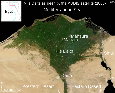
With support form the National Aeronautics and Space Administration (NASA), the European Space Agency (ESA), and the Government of Egypt, I studied land subsidence and coastal erosion in the Nile Delta, using various InSAR techniques. Conventional Differential InSAR (DInSAR) and advanced Permanent Scatterer Interferometric (PSI) techniques were applied to detect and measure, in millimeter-level accuracy, land subsidence in Greater Cairo, Mahala and Mansura during 1993-2000. Also, areas of erosion and accretion along the Nile Delta coast were monitored and detected using tandem InSAR coherence and amplitude images created from ERS data. Some results from the Nile Delta project are posted in the next two pages.